Marine Strategy Framework Directive

This report presents outcomes and conclusions resulting from work undertaken on behalf of the Joint Nature Conservation Committee (JNCC) to examine options and assess approaches to the development of Marine Strategy Framework Directive (MSFD) indicators for the determination of shallow sublittoral rock habitat status in respect of achievement of Good Environmental Status (GES).

Anguilla Habitat Mapping Using Earth Observation

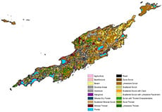
This project has used earth observation to produce a habitat map of Anguilla and it’s off shore cays looking at selected plant community groups with particular functional elements. This habitat mapping has used field studies undertaken by the Government of Anguilla and earth observation classification that can be subsequently used to show how the vegetation contributes to both biodiversity and other ecosystem services.

Anguilla Marine Habitat Mapping Using Earth Observation: Phase 2

This project forms phase 2 of the ‘Anguilla Habitat Mapping using Earth observation’ (Medcalf and Cameron, 2013), for the Department of Environment (DoE), Ministry of Home Affairs and Environment, Anguilla. It has used earth observation to produce a marine habitat map of the Anguilla archipelago looking at the primary benthic classes and derive a bathymetric dataset. The terrestrial habitat map from Phase 1 was also enhanced to include an extended classification for areas of mangrove, dry forest communities and calculations of canopy density.

Scottish Natural Heritage – Remote sensing methodology

This work is a continuation of previous studies, which outlined the potential for geoinformatic techniques and rule based approaches to use existing data to identify possible areas of upland Annex I habitat. This project consisted of two parts, a field validation campaign of the mapping produced previously, and then a demonstration of how the results from the fieldwork can be fed back into the rule base for the Western study area.

Natural Resources Planning Support System – SCCAN

The SCCAN project started in 2010 with the aim of delivering an ecosystem service mapping system that could assist people in taking an ecosystems approach in their decision making. SCCAN brings together information on a wide range of ecosystem services to allow users to weigh up and set priorities for the many competing demands that are placed on our natural resources. The aim is to provide the best mix of services, meeting societies needs while maintaining ecological resilience and the options for future use.

Making Earth Observation Work for UK Biodiversity Conservation (Phase 1, Part A)

Environment Systems Ltd., together with partners Team Projects Ltd., Callen-Lenz Associates Ltd. and Aberystwyth University, Institute of Geography and Earth Science was commissioned in October 2010 to undertake Phase 1 of a three Phase project to address habitat monitoring and surveillance needs in the UK, supporting the implementation of the UK Terrestrial Biodiversity Surveillance Strategy.