
Welcome
In the last two special editions of Sphere leading up to the COP26 summit in Glasgow in November we have focused on ‘Natural Capital’ and ‘Net Zero.’ On the eve of the Glasgow summit in this special edition of Sphere we are concentrating on ‘Biodiversity.’ For many, today’s imperatives are tackling climate change, the reduction of emissions and new ways of generating energy, biodiversity tends to get forgotten. In this edition, we look at some of the ways in which we are helping to introduce nature-based solutions that seek to add resilience, restore ecosystems and find new opportunities to plant trees, re-wild, and mitigate the effects of climate change, whilst promoting greater biodiversity.
Contents
Why is Biodiversity so important?
Ecosystem Resilience Guide
Due Negligence Report
Cotswolds Area of Outstanding Natural Beauty
CivTech – Scottish Peatland Restoration
Windfarms – Ecological Considerations
Understanding Ramsar wetland dynamics for marine conservation and environmental resilience
Why is Biodiversity so important?
A less wild world is a less stable world. Today, our world is less able to support the millions of species that have flourished over the millennia. No one organism, whether it be a tree or the smallest insect, is able to live in isolation. They live and work with countless others within ecosystems held together by complex and intimate relationships. This variety, complexity and interconnectivity we characterise as biodiversity. The biodiversity in ecosystems that thrive in the natural world provide us with a vast number of services for free, including the water we drink, or use to irrigate our crops, the air that we breathe and the materials that we use to build. However, our current way of life is threatening these natural ecosystems and the biodiversity within them.
In 2020, the Intergovernmental Science Policy Platform on Biodiversity published a global appraisal of the state of worldwide biodiversity and had a stark message. “The health of the ecosystems on which we and all other species depend is deteriorating more rapidly than ever. We are eroding the very foundations of our economies, livelihoods, food security, health and quality of life worldwide.”

The importance and complexity of the problems we face are daunting. To address them we have to understand what is going on, and continually monitor the situation so that we can understand what needs to be done. We must model the ecosystems that we are dealing with to inform the policy and actions that need to be taken. Moving forwards, we need to continue to monitor, adjust and enforce action so that we add resilience, restore and extend the ecosystems we have plundered in the past.
Much of Environment Systems’ work around the world is focused on unpacking the complexity of the natural world and describing it in ways that inform decisions and actions on the ground. This involves mapping and recording where habitats are, monitoring change, understanding place- based aspects of natural capital and the ecosystem services that underpin it. Looking forward we consider different scenarios for the impact of climate change seeking to identify spaces for opportunities which will secure the maximum impact of restoration activities on the ground.
Ecosystem Resilience Field Guide
Recently, Environment Systems, working with LDA Design, were tasked with producing an Ecosystem Resilience Field Guide by Natural Resources Wales on behalf of the Nature Recovery Action Plan Ecosystem Resilience and Restoration Group. The need to build ecosystem resilience is driven by the Wellbeing of Future Generations (Wales) Act and the Environment (Wales) Act.
Ecosystem resilience is the capacity of an ecosystem to deal with pressures and demands; resisting, recovering from or adapting to these whilst retaining their ability to deliver ecosystem services. A resilient ecosystem will demonstrate:
Diversity – including genetic diversity, species diversity, diversity within and between ecosystems, and structural diversity.
Extent – where its area is sufficiently large to sustain populations, support ecological processes and cope with negative edge effects like predation.
Condition – where the physical environment can support a comprehensive range of organisms and healthy populations.
Connectivity – where organisms can move within and between different ecosystems, from foraging or migration of individuals, through dispersal of seeds and genes, to the major shifts of species’ populations to adjust to a changing climate.
The guide sets out to inspire people to take action for sustainable land management, demystifying the concept and assisting stakeholders to understand and help build ecosystem resilience on the ground. In many ways it is a practical guide with specific actions highlighted for townscapes, lowland, upland and coastal areas. It is illustrated with annotated photographs that help in the understanding of the practical measures such as tree planting, hedgerow restoration and specific crop and livestock management that can be taken.
The guide also looks forwards to 2050 to show what a resilient future might look like. As we move towards 2050, the way in which we choose to manage our land will increasingly be based on its ability to provide multiple ecosystem services, not just one or two; crops or timber for example. Not all land will be suited to providing all ecosystem services, but all land will have the potential to provide a variety of services, and its ability to do this will greatly depend upon the diversity extent, condition and connectivity of the ecosystems found there.

- Trees planted to diversify farm income, provide shelter for grazing animals (improving animal welfare), storing carbon and increasing habitat extent and diversity.
- Woodlands managed to create a diverse range of tree ages, species and structural types, improving habitat condition and diversity.
- Lowland habitats, like semi- natural grasslands and wetlands, restored and created to increase diversity, condition, extent and connectivity.
- Continuous hedgerows and field margins provide corridors for wildlife movement, and carbon storage when managed sympathetically; increases habitat connectivity.
- A mixed farming model with diverse crop rotations together with livestock, agroforestry and orchards support wildlife as well as maintaining soil fertility and controlling pests and diseases; increases diversity and condition.
- Riparian planting reduces soil erosion and sediment inputs into watercourses, provides beneficial shading and nutrients to watercourses, and improves condition.
- Fencing watercourses creates a buffer strip to prevent livestock access, reducing soil erosion and sediment inputs into watercourses, improving diversity and condition.
You can access the guide here.
Due Negligence Report
Will a due diligence regulation on illegal deforestation delink UK supply chains from deforestation?
The UK’s draft deforestation due diligence regulation, which is part of the Environment Bill currently making its way through Parliament, would make it mandatory for large companies to carry out due diligence to ensure that there is no illegal deforestation in their agricultural and forestry supply chains. However, legal deforestation and conversion of natural land for agriculture could continue. What are the implications of this?
This Due Negligence report, commissioned by the World Wildlife Fund and prepared by 3Keel and Environment Systems, presents an analysis of the potential consequences of the UK’s proposed due diligence obligation. Legality would be defined by producer country regulations. Clearly the issue of deforestation has huge implications for existing carbon stores and biodiversity.

The report had a number of key findings:
- A regulation based on excluding illegal deforestation may only have limited impact on the overall conversion of natural land associated with UK supply chains.
- A regulation based on illegal deforestation will be harder to implement and enforce than one based on all (legal and illegal) deforestation and conversion, due to the complexity of legal structures in producing countries, the variation in what is defined as legal between countries, and the lack of comprehensive, publicly available data on legality.
- Focusing on forests alone, rather than all ecosystems, puts those other ecosystems and the people and species that live in, and depend on them, at risk.
- Getting the right model of due diligence and effective penalties for non- compliance matters.
A question this poses, for example, is how much deforestation is likely to happen in the UK’s Brazilian soy supply chain by 2030? Depending on the rate of deforestation and conversion in Brazil under the different scenarios, conversion of 36-59,000 hectares of natural vegetation would be directly attributable to UK supply chains between 2021 and 2030. This vegetation stores 18- 30 million tonnes of carbon, equivalent to between 4-7% of the UK’s current annual domestic Greenhouse Gas emissions. The impact on biodiversity is dramatic. Out of 2,462 species of plants and animals present in the biome, a quarter of them are on the IUCN (International Union for Conservation of Nature) Red List of Threatened Species, a critical indicator of the health of the world’s biodiversity. The implications for the ecosystems and the future wellbeing of the species that thrive within them are stark.
With this detailed analysis available, policy makers have the evidence to draw up regulations that will work effectively. The WWF Due Negligence Report is a significant call to action with recommendations for the UK Government to strengthen its legislation. If this is acted upon, supply chain companies will have an effective and auditable system with which they can work. As COP26 President, the UK would also be in a stronger position to encourage others to do likewise. Failure to act would be more than just a missed opportunity.
You can read and download the report here.
Cotswolds Area of Outstanding Natural Beauty
The Cotswolds National Landscape is a designated Area of Outstanding Natural Beauty (AONB). It is made up of 204,270 hectares spanning six counties and a variety of landscapes. In this pilot project, funded by Natural England, the aim was to investigate how an integrated approach using offline ecosystem service mapping together with an online dashboard could help this and other AONBs / National Landscapes in meeting their nature recovery reporting requirements. This process is often compromised by heterogeneous or incomplete data.
Environment Systems was tasked with creating the ecosystem service maps using its SENCE ecosystem service modelling tool.
The ecosystem service modelling focused on four services: carbon storage, water quality regulation, water flow regulation (natural flood management), and farming. Additionally, nature recovery networks were modelled to highlight areas of particular biodiversity value. Working closely with project partner Triage, a data dashboard was conceived which could support nature recovery reporting and form the basis for monitoring moving forwards.
Using the web-based data dashboard implemented by Triage, the data can be viewed, queried, and summarised by a wide range of stakeholders without requiring the user to have Geographical Information System expertise. The data is presented in a
range of tabs (Habitats, Nature Recovery, and each of the ecosystem services, which are in turn broken down into their component parts (e.g. stock and opportunities for most of the ecosystem services).
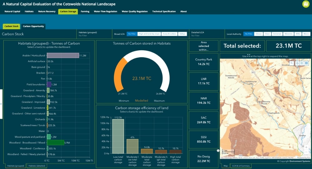
The carbon stock dashboard shows the values produced on a by-pixel basis, but these are then converted to a format more suitable for reporting. On the dashboard, this information is converted to the actual storage in tonnes of Carbon, so that, when filtering, for example, to a broad habitat the bar charts will show the total amount of carbon stored within that habitat.
The project has demonstrated that the integration of ecosystem service modelling with the online dashboard was particularly helpful to Cotswolds staff, as it meant that data could be summarised flexibly to match reporting areas without requiring any in-house data manipulation.
CivTech – Scottish Peatland Restoration
Peat is a big thing in Scotland covering 20% of the land area, of which 80% is degraded. Among the Scottish Government’s top priorities are the twin challenges of the climate change emergency and biodiversity loss. It has recently committed £250 million to peatland restoration over the next 10 years but why has it done this, and why is peatland so important?
Peatlands formed over thousands of years are incredibly special habitats, made up of highly adapted plant species and home to a range of rare and important wildlife. These include ground nesting birds (such as curlew, golden plover and hen harrier), red deer, mountain hares, lizards, amphibians, insect-eating sundew plants and a host of invertebrates all of which thrive on peatlands. Peatlands are important for humans too as most of Scotland’s drinking water is filtered through them.

Environment Systems passed the Exploration Stage and now, together with its partners, the Tweed Forum Ltd, Land & Habitat Ltd and Sarah Robinson (a land and habitat Ecologist with extensive experience of Scottish peatlands), is moving on to the ‘Accelerator Stage.’ This stage is focused on the solution which will use our SENCE natural capital evaluation tool, plus satellite data analytics to develop a minimum viable product. This will be an online tool to provide area-based peatland restoration prioritisation to enable policy makers, land managers and contractors and the finance community to pinpoint areas of peatland requiring restoration. This will help Scotland to transition to net zero and restore one of its most valuable landscapes and significant carbon store. This solution would also be applicable to other peatland areas across the world.
Wind Farms – Ecological Considerations
Green energy production is of growing importance in Wales. Recent Welsh government planning development policy has identified tracts of land in mid-Wales for onshore wind projects. There are several prospective wind farms at the important planning stages, for although wind farms deliver an important renewable energy resource there are many concerns surrounding their environmental impact. Two of these projects are currently keeping Environment Systems’ team of ecologists busy. The studies currently being undertaken for an Ecological Impact Assessment include a focus on habitats, bats, mammals and reptiles. Birds are also covered under an Ornithological Impact Assessment. These are all necessary as part of the planning process.

is a detailed understanding of species, how they behave at different times of the year and under varying weather conditions. This will inform the micrositing of the turbines, for example to avoid fragmenting populations of great crested newt or important features used by badgers, otters and other protected species.
Times of higher-level activity for bats and birds are also important to understand,
as this will inform turbine feathering and curtailment – spinning down of turbines during specific climatic conditions. Feathering involves pitching the blades out of the wind when turbines are idling (not generating energy), to ensure speeds of less than two revolutions per minute.
Curtailment doesn’t necessarily mean loss of energy production, as smart-curtailment programs monitor climatic conditions at each turbine, and adjust for the local conditions. Implementing an increased ‘cut-in’ speed (the speed at which the turbine begins to spin and generate power) of approximately 5.75 metres/second reduces the majority of bat collision-related fatalities.
Measures taken to reduce bird collision- related fatalities include the painting of a single blade either black or with UV-paint, which is still a novel technique, particularly in the UK.
Understanding Ramsar wetland dynamics for marine conservation and environmental resilience

The project sets out to provide new evidence of the dynamic resilience of the T&CIs wetlands and how they support biodiversity, coastal protection, and natural capital in order to help make a scientifically robust case for the expansion of the protected area and to help people understand and value of this incredible resource. We will use our expertise in environmental modelling, mapping and monitoring to evaluate historic change in the wetlands, show how future climate could impact the current wetland dynamics and provide evidence to review the current Ramsar extent.
The project is funded under the UK Government’s Darwin Plus initiative. We have a great project team with the T&CIs Government Department of Environment and Resources, JNCC, and the Marine Conservation Society (MCS). MCS will provide data inputs from their long-term turtle satellite tagging programme, largely conducted in the Ramsar sites and, together with local consultants and the University of Exeter, coordinate ground-truthed mapping of the turtle foraging habitat.
To help the people on the islands and the policy makers understand the significance of these areas the work will include the creation of an open, interactive online monitoring intelligence dashboard. This will enable viewing of information about the Ramsar wetlands and be updated frequently using information gathered from remote sensing data. Another important element of the project is training to build the technical and scientific capacity of local staff to enable them to continue and develop the long-term management and conservation of the wetlands.