
Welcome
It has been a peculiar year and despite everything we are busy and working from home with full access to all our data and technology. We continue to deliver lots of exciting projects. This issue of Sphere demonstrates the diversity of activity across the company, and how we are leveraging our expertise and technology to great effect and across the world.
Contents
Project News
Crop Suitability Modelling In Wales
EO4cultivar – Tecbaco
Current Relative Value for ecosystem resilience (CuRVe)
Better Targeting of Information and Advice on Protected Areas in Scotland
Drone Season
Crop Suitability Modelling In Wales
According to the latest Met Office UK Climate Projections (UKCP18), the UK is going to experience wetter winters, warmer and drier summers, increased incidence of storms and extreme weather, and rising sea levels. Soil is a complex medium, and different soil types, in different landscape contexts, are expected to respond to climatic changes to different extents. This creates a great deal of uncertainty in how climate change could impact on agricultural production in Wales. Environment Systems has completed a two-year project led by Welsh Government, using new climate projection and Agricultural Land Classification (ALC) data to unravel this uncertainty. The project used soil and climate information to model land suitability for 118 different crop types, including some novel crops such as tea and almonds, under current conditions and nine projected climate change scenarios.

A variety of crops common to Wales and the UK were considered, including cereals, row crops, horticultural crops, orchard crops, timber crops and specialist crops. The outputs from the project take the form of GIS data files which contain the models for all 118 crops. The suitability modelling shows how the spatial extent of suitable ground for each crop changes with the climate in the different scenarios. The models tell us that the agricultural sector in Wales will be required to change in a relatively short period of time but not all parts of Wales will be affected in the same way, or to the same extent. The models provide an important source of evidence for policy makers, landowners and the agricultural industry as they prepare and plan for the future.
This project was led by Welsh Government Land, Nature and Forestry Division with partners Environment Systems Limited, RSK ADAS Limited and Cranfield University.
EO4cultivar – Tecbaco
We have reported before on the EO4cultivar project that we are leading in Latin America. Four years in, we are starting to see the results of the collaboration with commercial partners and here we look at three ways Tecbaco, a large international fruit supplier based in Colombia, is using our Agri-track services to good effect.
Cultivation Planning
It takes between nine and 12 months for a banana plant to produce a flower after being planted, and it takes another two to three months for the bananas to ripen. For this reason, cultivation planning is necessary to ensure that the bananas can be brought to market at the best time. Agri-track data, provided by Environment Systems, enables Tecbaco to monitor many different field situations, keeping agronomists informed, enabling advanced cultivation planning and speedy response to poor crop performance or adverse weather events. The data insights enable crop management and controlled market entry making a significant impact.
Addressing Poor Crop Health
Environment Systems supply satellite imagery and analytics for Tecbaco farmers and their agronomists. Close analysis of imagery for June 2019 indicated that one of their banana grower’s fields stood out from the rest. It was clear that the health of the crop growing in this plot was suboptimal. Access to imagery enabled a quick investigation of farming practices on the ground to explain and rectify the issue.
Responding to the advice of the Tecbaco agronomists, the farmer was able to bring his crop back to full health in less than two months. This remarkable result not only improved his own productivity but also contributed fully to Tecbaco’s output. Access to the data provided by Environment Systems enabled Tecbaco to identify a problem they did not know they had, and then act quickly, providing the farmer with the advice required to restore crop health and prevent any lasting reduction in productivity.
Wind Damage Assessment for an Insurance Claim
At the end of June 2019 strong winds affected several banana fields in Tecbaco plantations. Changes in Agri-track data, indicated that a total of 48 hectares of banana fields had been damaged by storms.

Using satellite imagery, it was easy to identify and measure the perimeter of the affected area and organise field teams to remove damaged trees and support the restoration effort to bring the area back into full productivity. The satellite data also enabled quantification of tree and fruit loss to report the extent of the damage for insurance purposes.
Current Relative Value for ecosystem resilience (CuRVe)
Natural Resources Wales (NRW) looks after the air, land, water, wildlife, plants and soil of the country for the benefit of its citizens. Earlier this year we produced a report and the CuRVe (Current Relative Value) map atlas for ecosystem resilience for NRW. This fulfils the policy background requirements where the sustainable management of natural resources is seen as key to maintaining and enhancing ecosystem resilience.
As there is no direct way to measure the resilience of an ecosystem this project trialled the DECCA approach, an experimental way of combining data. The DECCA approach is named after five attributes: Diversity, Extent, Condition, Connectivity, and Adaptability, all of which have a substantial effect on ecosystem resilience. For the CuRVe atlas, 16 factors, each a proxy for one of the attributes, were selected and mapped by interpreting and combining existing datasets and summarising them into 1 km reporting squares. All factors were brought together to create one overall current relative resilience map of Wales. Presented on an NRW web portal, the CuRVe atlas allows users to explore what drives the varying levels of resilience across Wales to help target policy and other intervention effectively.

Of particular interest in this study were the number of discrete habitat networks. For this map, ecological network maps for bog, fen, grassland, heathland, sand dunes, and woodland were used to identify the number of networks present within each reporting square. In some squares, as many as 5 out of 6 networks are present. These areas of overlap act as major nodes between various habitat networks across Wales which is likely to make them highly important to ecosystem resilience and connectivity, something not identified in previous studies of the Welsh uplands.
Better Targeting of Information and Advice on Protected Areas in Scotland
This was a proof of concept project for Scottish Natural Heritage (SNH). It was initiated in an effort to free-up planning officer time by enabling land managers and developers to become better informed when considering changes in management or a building development project, on a Protected Area in Scotland. The result is an easy- to-use and engaging online digital service prototype providing step-by-step guidance in combination with a map interface, to identify and select target areas and deliver information. A ‘Chatbot’ is used to enable a simple conversation-based user experience, ensuring that users receive relevant information in an understandable way.

This project was led by Informed Solutions with Environment Systems’ SENCE (Spatial Evidence for Natural Capital Evaluation) product delivering the natural capital evaluation mapping and ecological scenario modelling. A third partner, LandInform, looked after the policy and data context within which SNH and its stakeholders operate to ensure better use of the data in helping SNH customers.
The partnership of Informed Solutions, Environment Systems and LandInform offers an unrivalled convergence of expertise and experience in digital technology, data analytics and systems integration combined with a deep understanding of environmental data and natural capital models. There is significant potential for future development, both in the UK and across the globe.
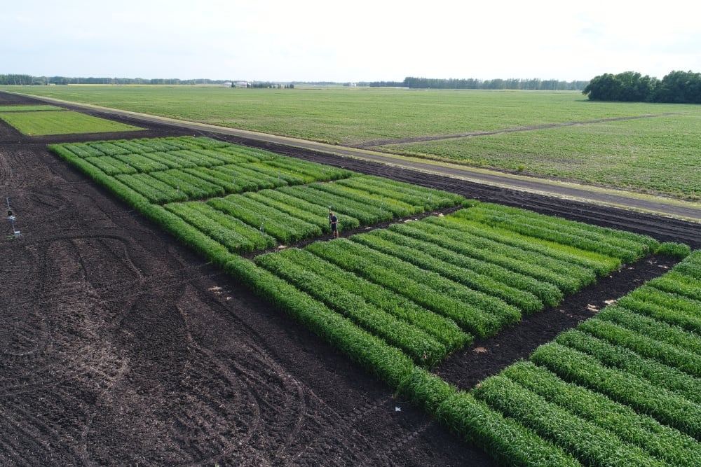
Drone Season
It’s that time of year again and we are carrying out a lot of drone surveys for customers both in the UK and in North America.
Environment Systems has been using drones for over five years and in that time sensor and platform technology has continuously evolved delivering improved spatial and spectral resolution along with greatly extended flight times. We continue to embrace new technical advances and are expanding our drone operator network. Today, our data processing workflows enable us to process and deliver analysis ready maps and analytics to our customers fast.
Drones are useful for capturing the detail required for crop trials and other detailed analyses. Crop trial analysis can cover a number of different parameters including, nitrogen, crop variety, crop treatment and sowing width. We process the data and deliver it to customers in a number of different ways including business intelligence data dashboards.
Another project is carrying out an analysis of grassland pasture in Wales to assess productivity over time. The project compares our drone imagery with Sentinel-1 and -2 satellite imagery, delivered via our Data Services platform. This is a two-year project with the goal of developing a ‘hands free’ online tool to help farmers estimate average grass cover and reduce the need to go out into the field to collect data, a time consuming and onerous activity.